15th Apr, 2021 11:00
Fine & Classic - Live Online

75
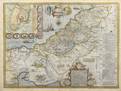
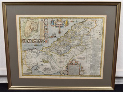
John Speed, Map of Canaan.
Canaan. Speed (John), Thomas Bassett & Richard Chiswell, 1651 [1676], hand-coloured engraved map, inset plan of Jerusalem.
Dimensions: 41.5cm x 54.5cm (16.25in x 21.5in)
* Speede's maps usually showed the land as it was experienced. Even if not to the levels of accuracy of a modern ordnance survey map, they strove to show the locations as they related to each other and the land on which they were situated. From the first though, Canaan was different. Canaan is a land created in two places. The first is on the ground, in the towns, rivers, mountains and other features of geography, both natural and man-made. The other is in the mind, particularly of Christians, who will be comparing the land they see with that they first experienced through the words of the Bible. This was especially true for readers of the King James Version for whom this map was an integral part of their reading of the Bible. The map was first featured in the Geneva Bible as published by Robert Barker. Speede was still a tailor when he first became involved with this map - his first cartographic work. John More (credited on the map) did the first work on it whilst a Fellow of Christ's, Cambridge. After his death in 1592 it was passed to Speede who finished it and received a licence to print and insert it in the KJV for ten years from 1610. By the time the KJV was first published in 1611, Speede was already one of the most important cartographers in England, and busily working on his famous county maps, many of which feature in this sale. Interestingly, this map did not feature in the first issue of Speede's Prospect, but was added later. Despite current knowledge, Speede's map contains oddities to the modern eye. Most specifically the coastline follows the Ptolemaic slump, despite the actual coastline being known. This is part of the purpose of this map. The map is not the territory. The map does not even follow Ptolemy's desire to be accurate (within the limits of contemporary knowledge), but rather to use Ptolemy's coast as a short-hand to evoke the era. This map sets out to create a place that never existed, it is not a tool for explorers of anything but the words on a page. Speede's map shows events, places, people, and details from across Biblical history. The Dead Sea is the Lake of Sodom, Pharoah's armies (equipped as expected in Jacobean armour) drown even as Judas hangs himself. Ancient Kingdoms share space with Jewish settlements. The inset map of Jerusalem lists important places in the story of the Passion, but they are not a pilgrim map, rather a reminder, a positioning in a space not physical but mental. Despite all this, there are suggestions that the map inhabits a 'real' world and is not merely a fairytale realm. The new habit for framing the map in longitude and latitude is followed. Whilst a traveller could never hope to find a location using them, it reminds the reader that the place (and by extension the events depicted and remembered) is real. The leviathan frolics in the depths but this is not to say there are literal monsters beneath the waves (nor even to recall Jonah's whale) but rather to remind of the troubles of travel. Even the choice of name is suggestive. Whilst Christians today might accept 'The Holy Land', to a Protestant this would be redolent of Papistry, whilst other more accurate names might be overly Jewish in suggestion. Canaan is the ancient name, all other names (whether Israel or Outremer) are tranistory compared to the Biblical truth which underlies all. In Protestant eyes, the holy places had no intrinsic spiritual value and visiting them was unnecessary - as the map reminds us, ''Nether in Ierusalem, nor in this Mountaine shal ye worship''. The idea of pilgrimage was, if not anathema, highly suspicious. Whilst English ships crossed the seas, they did so for trade, and there was little to trade in Palestine - not even treacle in Gilead. For the strict Protestant Englishman, the critical thing was your relationship with God through Christ, the rest was confusing trappings which got in the way. This map was all you needed to give a context to your reading of the Bible, and the experience of the Word would open you to God's Grace.
This is a 'live online' auction - you can bid from the comfort of your own home using our free live bidding service. Condition reports and additional condition report images can be requested and seen in the 'Condition Report' tab below if present.
Sold for £650
Auction: Fine & Classic - Live Online, 15th Apr, 2021
Sell a similar item
Please complete the form below. To help us with your valuation, please attach at least 1 clear photograph of your item.

